MOJANDA | Global Signal Compatibility: Teaching the Chip to Understand More Constellations

From the Horizon to the Centimeter
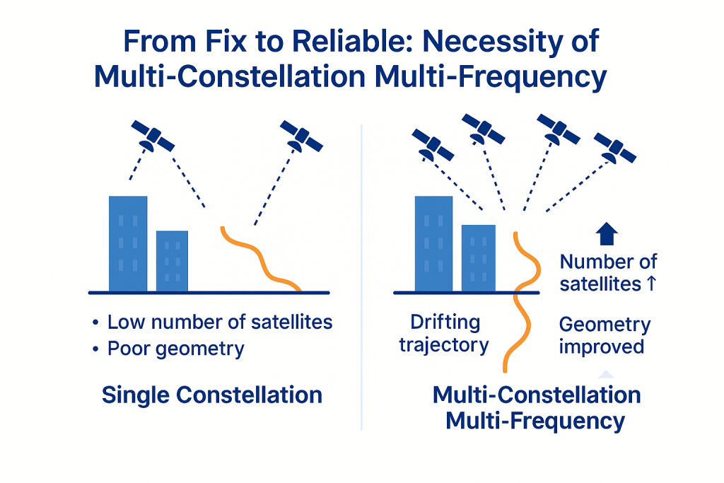
1️⃣ Why Multi-Constellation, Multi-Frequency? — From “Can Locate” to “Can Be Trusted”
In open sky, a single constellation can deliver decent results. But the moment you enter urban canyons, underpasses, or high-latitude regions, the number of visible satellites, their geometric distribution, and signal quality all degrade rapidly. The path from “can locate” to “can be trusted” doesn’t lie in fine-tuning a single algorithm — it lies in embracing more constellations and more frequency bands and making them work in concert. That is the essence of multi-constellation, multi-frequency GNSS.
2️⃣ The “Linguistics” of Constellations — More Than One Grammar for the Chip to Decode (What)
The world’s major GNSS systems include GPS, GLONASS, Galileo, BeiDou, and QZSS. They differ in time reference, signal encoding, and frequency band allocation:
- Frequency bands: L1/L2/L5, B1/B2, and others — multi-frequency observations enable cross-validation and help mitigate ionospheric and multipath effects;
- Timescales: Each system maintains its own time standard and synchronization error; without unification, cross-system bias drift is inevitable;
- Models: Orbital, tropospheric/ionospheric, and satellite clock correction models differ across systems — misalignment degrades fusion quality.
True “compatibility,” therefore, is not simply “receiving more signal streams.” It means translating sentences written in different grammars into a single language the solver can understand: 1) frequency protocol parsing; 2) cross-constellation time alignment (PPS-level); 3) parallel fusion of orbital and ionospheric models. Only then can multi-constellation data truly “perform together on the same stage.”
3️⃣ Multi-Constellation Coherence Fusion: How MOJANDA Turns “Many Voices” into One (How)
At the core of MOJANDA lies a multi-constellation coherence fusion algorithm built around a three-step approach: align — weight — filter:
- Inter-System Bias Correction: Systematic biases between constellations are estimated and eliminated under a unified reference frame using observation equations, bringing all sources onto “the same ruler.”
- Dynamic Weighted Solving (SNR × Geometry): Satellites and frequency bands are weighted according to carrier-to-noise ratio (CN₀) and geometric distribution (GDOP), ensuring that weak signals and poor geometry don’t drag performance down.
- Time–Frequency Joint Filtering: Using a unified time axis as the backbone, phase and pseudorange observations across multiple frequency bands are jointly filtered to suppress jitter errors caused by asynchronous sampling.
In typical urban obstruction scenarios, internal comparative validation shows: convergence speed improved by approximately 45% and positioning continuity improved by approximately 60% (relative to conventional dual-constellation GPS + BeiDou solutions), with significantly reduced recovery time following sudden signal blockage.
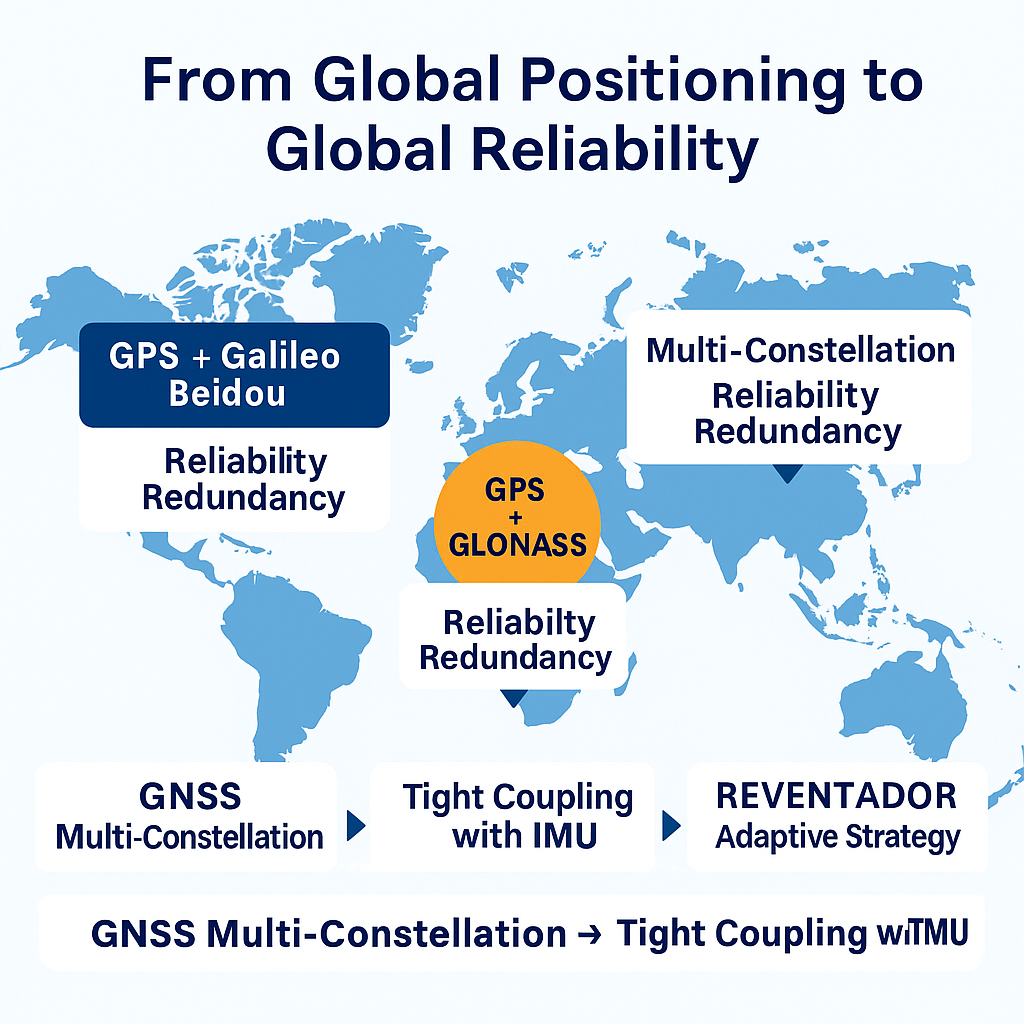
4️⃣ The Engineering Value of “Global Reliability” — The Same Confidence Under Any Sky (So What)
For automotive-grade applications, the value of global compatibility is reliability through redundancy:
- Different latitudes, different ecosystems: Northern hemisphere (denser BeiDou + Galileo visibility), South America/Africa (fuller GPS + GLONASS coverage), polar routes (multi-constellation switching to avoid blind zones);
- Different scenarios, different obstructions: Urban canyons, interchange ramps, tunnel entrances, tree-lined roads, and other complex environments benefit from multi-constellation, multi-frequency improvements in availability and recoverability;
- From chip to system: Tightly coupled with an IMU, multi-constellation data becomes the foundation of positioning continuity; combined with REVENTADOR’s adaptive strategy, multi-source information is dynamically arbitrated by scene, delivering true system-level reliability.
5️⃣ When the Chip Understands Constellations, Positioning Truly Understands the World (Vision)
Multi-constellation compatibility is not about “stacking complexity” — it is about transforming spatiotemporal evidence from diverse sources into a single, verifiable form of certainty. In MOJANDA, it represents a long-term path of “openness — collaboration — adaptability”: open to more constellations and frequency bands, collaborative across a unified time axis and reference frame, and adaptive to regional and scenario-specific variation. When the chip truly “understands constellations,” the positioning system earns the same confidence under any sky.
About MCT
MCT (毫厘智能) is an innovative company focused on attitude sensing and absolute positioning for the Physical AI era. Leveraging artificial intelligence as our core technology and a “data-driven, hardware-software integrated” strategy, we develop and deliver comprehensive attitude sensing and absolute positioning solutions — spanning both hardware and software — serving the fields of embodied intelligence, urban-area assisted driving, low-altitude economy, robotics, and intelligent devices. Built on our proprietary automotive-grade BeiDou high-precision chips and modules, and integrating high-precision IMU, vision, and LiDAR sensor technologies with large-scale data, MCT provides more reliable, safer, and more precise technical support for autonomous planning and automatic control, continuously enhancing the spatial awareness capabilities of moving platforms.
Want to learn more about MCT’s latest developments?
Visit www.mctech.ai / www.mctai.cn, or follow our WeChat Official Account: 「毫厘智能 MCT」.