Chapter 2 | Lighthouses in the Sky: How GNSS Tells Us Where We Are
Prologue: An Invisible Line of Signal
Five o’clock in the morning. The sky over the Northern Hemisphere is still a deep shade of blue.
More than 30 satellites in orbit are quietly broadcasting their signals.
Those signals travel over 20,000 kilometers, piercing through the ionosphere and atmosphere before reaching the ground.
Almost simultaneously, the phone in your pocket, the display unit in your car, and the antenna on a drone are all receiving the same information —
Every signal carries a precise timestamp.
This is humanity’s largest lighthouse network: the Global Navigation Satellite System (GNSS). It keeps the entire world operating within a single, unified coordinate framework.
I. From GPS to GNSS: Humanity’s Interstellar Positioning Network
In the 1970s, the United States developed GPS — the world’s first satellite navigation system. The Soviet Union’s GLONASS, Europe’s Galileo, and China’s BeiDou followed in succession. Together, these systems form what we know today as GNSS (Global Navigation Satellite System).
The core concept behind GNSS is elegantly simple:
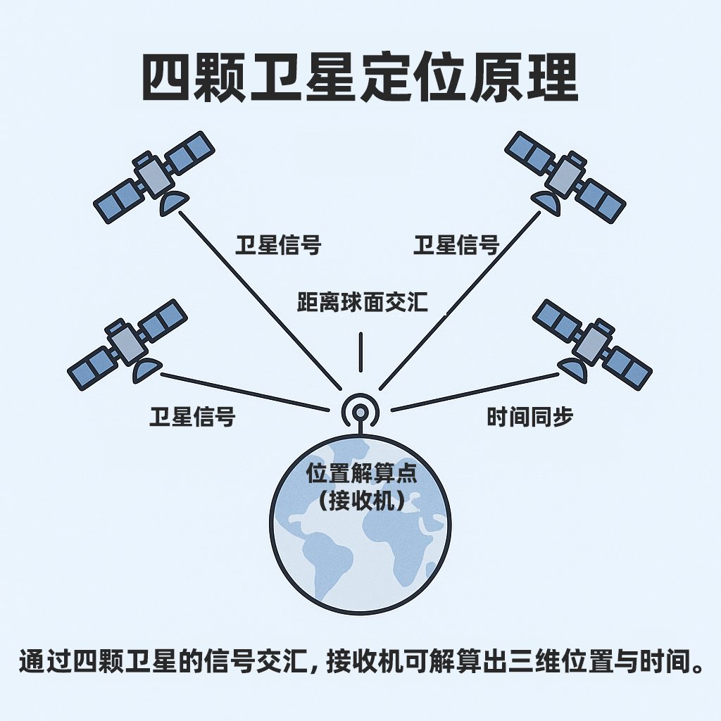
“If I know the positions of several satellites and my distance from each of them, I can determine exactly where I am.”
Any point on Earth that can “see” at least 4 satellites can calculate its own three-dimensional coordinates.
It sounds like magic — but it is really just a game of time and distance.
II. How It Works: A Speed-of-Light Race Against the Satellites
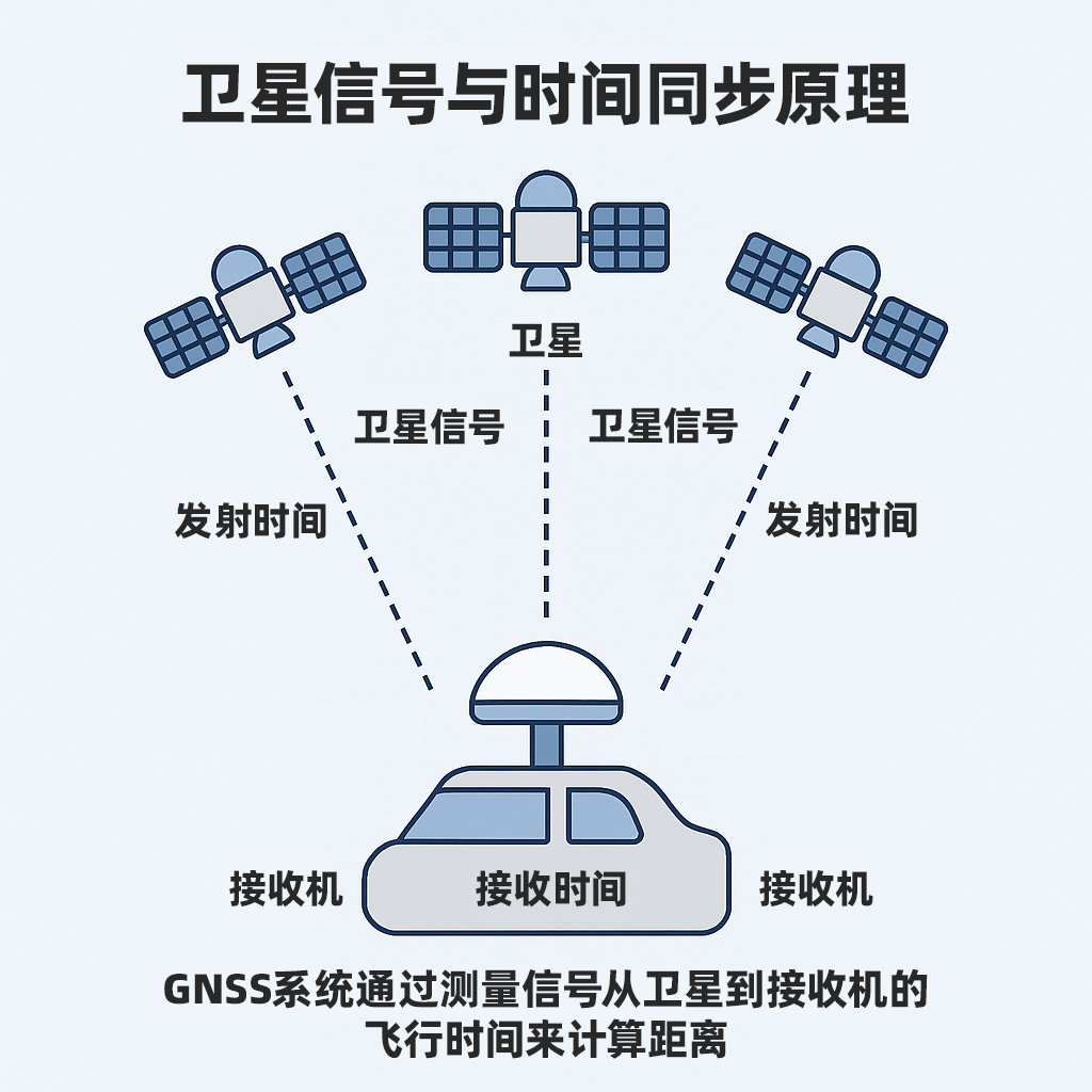
Every satellite continuously broadcasts its identity and the precise time of transmission.
The receiver records the time it takes for each signal to arrive, then multiplies that time difference by the speed of light to calculate the distance.
With four satellites, four equations can be solved simultaneously to yield a three-dimensional position and a clock error correction.
In practice, however, things are far from perfect.
Signals are delayed as they pass through the atmosphere; the clocks in both satellites and receivers experience minor drift;
and in urban environments, tall buildings can reflect signals — causing the receiver to register false distances.
This is where the gap between hardware and algorithm capability becomes apparent. Consumer-grade devices may carry errors of several meters, whereas automotive-grade modules such as MOJANDA achieve centimeter-level accuracy through multi-frequency signal reception, anti-interference RF design, and precision clock synchronization.
Precision is not merely a victory of computing power — it is, above all, a victory of time.
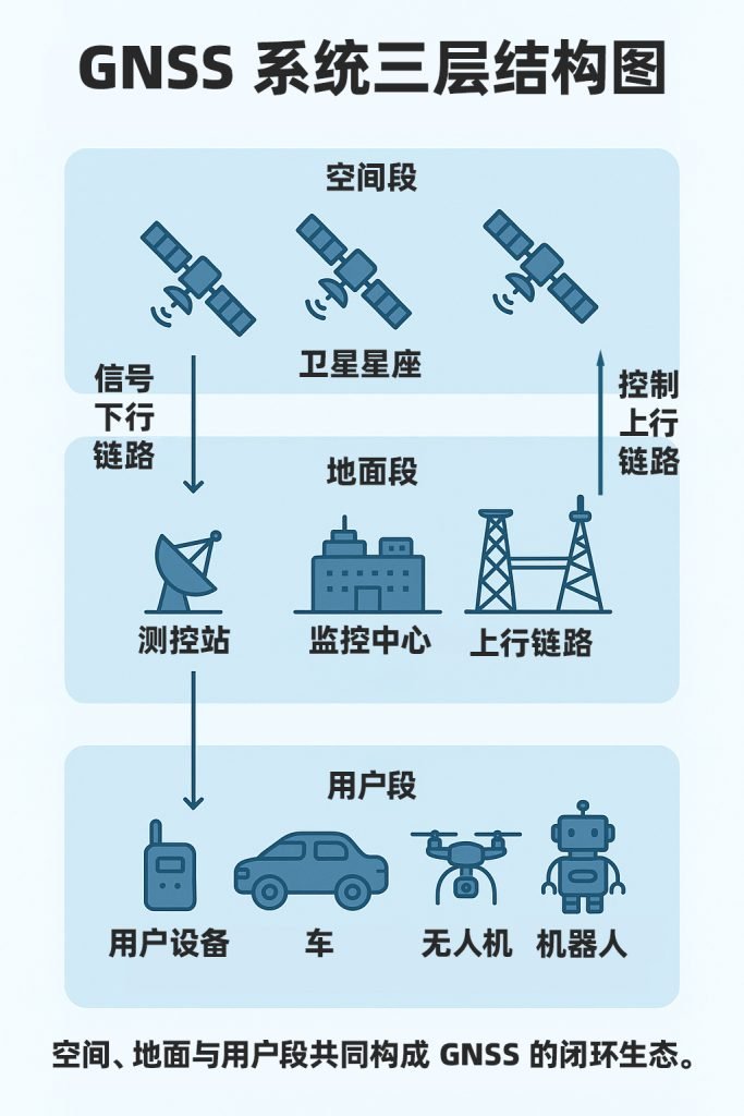
III. The Architecture of GNSS: A Three-Tier Symphony
A complete GNSS system is composed of three segments:
- Space Segment: The constellation of satellites in orbit;
- Control Segment: Ground monitoring stations and master control centers responsible for orbit correction and time synchronization;
- User Segment: Receiving devices such as smartphones, vehicles, and drones.
The coordinated operation of these segments forms a self-consistent spatiotemporal network.
Satellites relay spatial coordinates, ground infrastructure maintains time consistency, and end-user devices perform information fusion.
This is the physical backbone of spatiotemporal awareness.
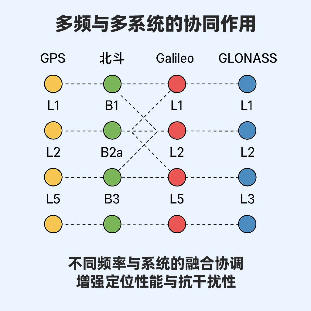
IV. Multi-Frequency, Multi-Constellation: The Foundation of Reliability
One of the most significant advances in GNSS has been the adoption of multi-frequency and multi-constellation operation.
Early GPS relied solely on a single-frequency signal (L1 band), which was susceptible to ionospheric delay in challenging environments.
Modern automotive-grade chips simultaneously receive L1/L2/L5 signals, as well as BeiDou’s three-frequency B1/B2a/B3 signals, enabling effective error cancellation.
More importantly: multi-constellation redundancy delivers reliability. When urban canyons block certain satellites, the system automatically switches to visible alternatives. When signals are disrupted, the chip leverages data fusion algorithms to maintain a stable output.
The integrated hardware-software design of the MOJANDA chip embodies exactly this philosophy: the RF front-end handles physical interference rejection, while the algorithm and data layer manages dynamic modeling and correction. Together, they ensure that positioning is not merely accurate — it is consistent.
V. From Signal to Understanding: The Future of GNSS
The ultimate destination of satellite navigation is not “positioning” — it is “understanding.”
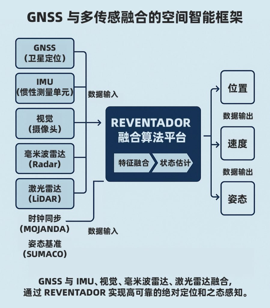
The GNSS of the future will do more than deliver coordinates; it will serve as the foundational data source for spatial intelligence.
When fused with sensors such as IMU, vision, and radar, it enables machines to develop genuine spatial cognition.
The REVENTADOR platform is exactly this kind of fusion paradigm.
It employs filtering and graph optimization algorithms to combine the absolute position provided by GNSS with the relative motion from inertial navigation and the spatial constraints from visual features.
The result: autonomous vehicles, drones, and robots can all achieve continuous, reliable navigation in complex environments.
“From knowing where we are to understanding the world around us — GNSS is only the first step.”
VI. Reflections and Outlook
Decades ago, humans looked up at the stars and asked the satellites: “Where am I?”
Today, machines are asking us the very same question.
GNSS has given the world a shared coordinate system — but the true future lies in enabling every intelligent agent to operate within that system safely, autonomously, and reliably.
In that world, “positioning” will no longer mean simply finding your location — it will mean understanding your place.
Further Reading
- Paul D. Groves: Principles of GNSS, Inertial, and Multisensor Integrated Navigation Systems
- Kaplan & Hegarty: Understanding GPS/GNSS: Principles and Applications (3rd Edition)
- Dana Mackenzie: The Universe in Zero Words: The Story of Mathematics as Told through Equations
About MCT
MCT (毫厘智能) is an innovative company specializing in attitude sensing and absolute positioning for the Physical AI era. With artificial intelligence at its core, MCT follows a “data-driven, hardware-software integrated” strategy to develop and deliver comprehensive attitude sensing and absolute positioning solutions — serving fields including embodied intelligence, urban assisted driving, low-altitude economy, robotics, and intelligent devices. Built on its proprietary automotive-grade BeiDou high-precision chips and modules, MCT integrates high-precision IMU, vision, and radar sensor technologies with large-scale data assets to provide more reliable, safer, and more precise support for autonomous planning and automatic control, continuously advancing the spatial perception capabilities of intelligent platforms.
Want to learn more about MCT? Visit www.mctech.ai / www.mctai.cn, or follow our WeChat Official Account: 毫厘智能 MCT.