Part 5 | When Satellite Signals Vanish: Maintaining Orientation in the Dark


Prologue: Those Few Seconds in the Tunnel
You’ve almost certainly experienced this moment:
You drive into a tunnel, the navigation signal cuts out instantly, and the blue dot on the map disappears.
A few seconds later, it reappears — as if nothing had happened.
Behind that brief “disappearance” lies a complex technological relay process.
When satellite signals cannot reach the surface, the system must use other means to “keep computing,”
otherwise the machine becomes like a blindfolded person — losing all sense of direction in the dark.
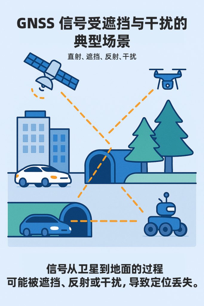
1. Why Do Signals Disappear?
GNSS signals are far more fragile than we might assume. Transmitted from satellites over 20,000 kilometers away, they arrive at the surface with a power of only around –130 dBm — weaker than the Earth’s background noise.
As a result, they are easily disrupted by a wide range of factors:
- Obstruction: tall buildings, tunnels, trees, and even the human body;
- Reflection: glass curtain walls and steel structures causing multipath errors;
- Interference: electromagnetic noise from communication devices, radar, and Wi-Fi;
- Ionospheric disturbance: signals delayed or bent during propagation.
The inherent vulnerability of GNSS means it cannot independently sustain continuous, reliable navigation.
The core of reliable positioning lies in maintaining spatial awareness even when signals vanish.
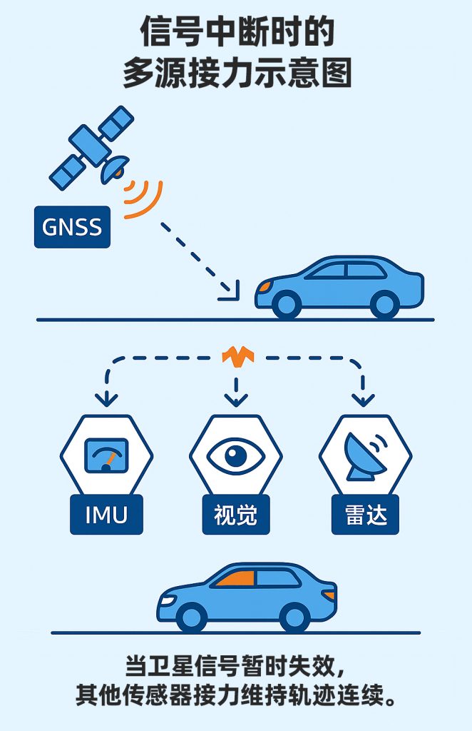
2. From “Signal Loss” to “Data Relay”
When satellite signals are interrupted, the system does not go blind immediately.
At that point, the IMU (Inertial Measurement Unit) and other sensors step in:
The IMU uses acceleration and angular velocity to estimate displacement;
Odometers record wheel speed and directional changes;
Vision or radar systems provide environmental feature matching.
These inputs are fused by algorithms into a continuous trajectory prediction,
and once the signal is restored, GNSS is used to correct accumulated errors.
Within MCT’s architecture, this relay process is orchestrated by the REVENTADOR fusion algorithm platform, which takes data from MOJANDA and SUMACO as inputs, and applies real-time filtering and Integrity Check mechanisms to ensure smooth, uninterrupted trajectory output across the entire system.
When the satellites go silent, the algorithms speak.
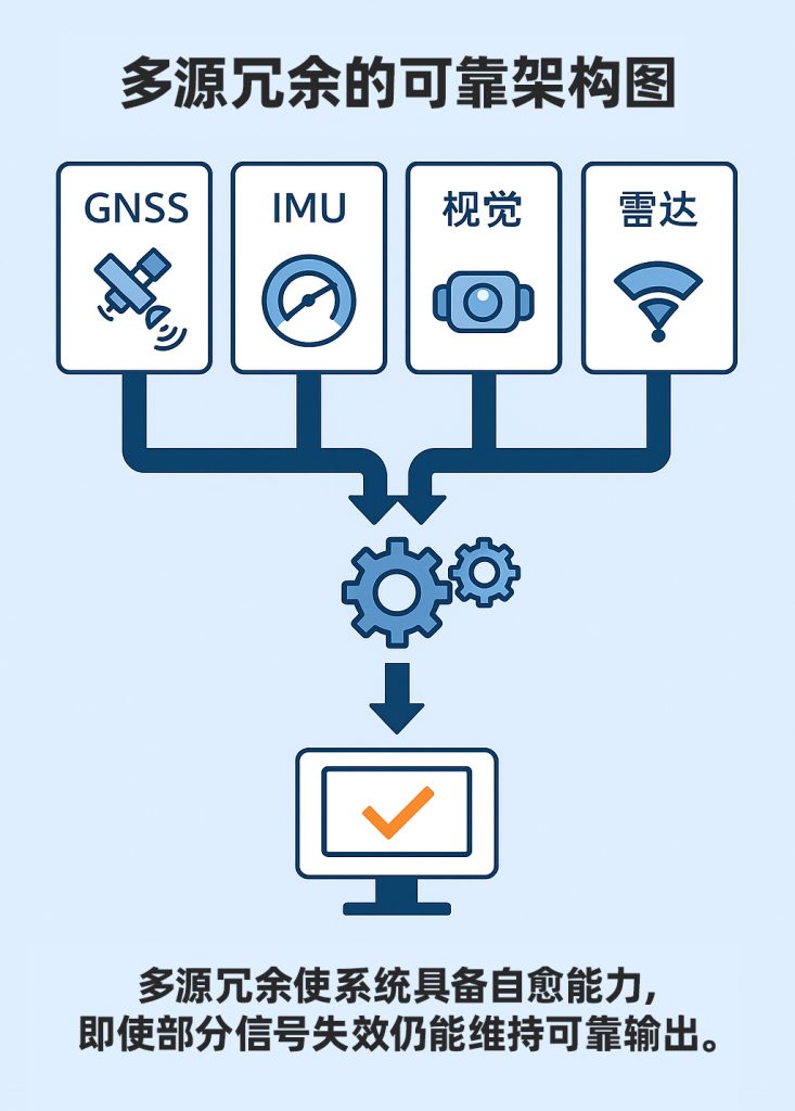
3. Redundancy: The Second Line of Defense
Reliability does not mean never failing — it means always having a backup. In positioning systems, redundancy is the foundation of reliability.
Throughout MCT’s integrated hardware-software architecture, every critical link incorporates redundant design:
- Multi-frequency redundancy: L1/L2/L5 or B1/B2a/B3 bands operating in parallel — if one band is jammed, the others continue to provide a solution;
- Multi-constellation redundancy: GPS, BeiDou, Galileo, and GLONASS operating simultaneously;
- Multi-sensor redundancy: GNSS, IMU, vision, and radar mutually compensating for one another;
- Data redundancy: historical data buffering combined with dynamic filter updates.
These mechanisms ensure that when a single source fails, the system does not drop out —
it automatically switches to a trusted secondary solution path.
This “self-healing design” is what fundamentally distinguishes automotive-grade positioning systems from consumer navigation.
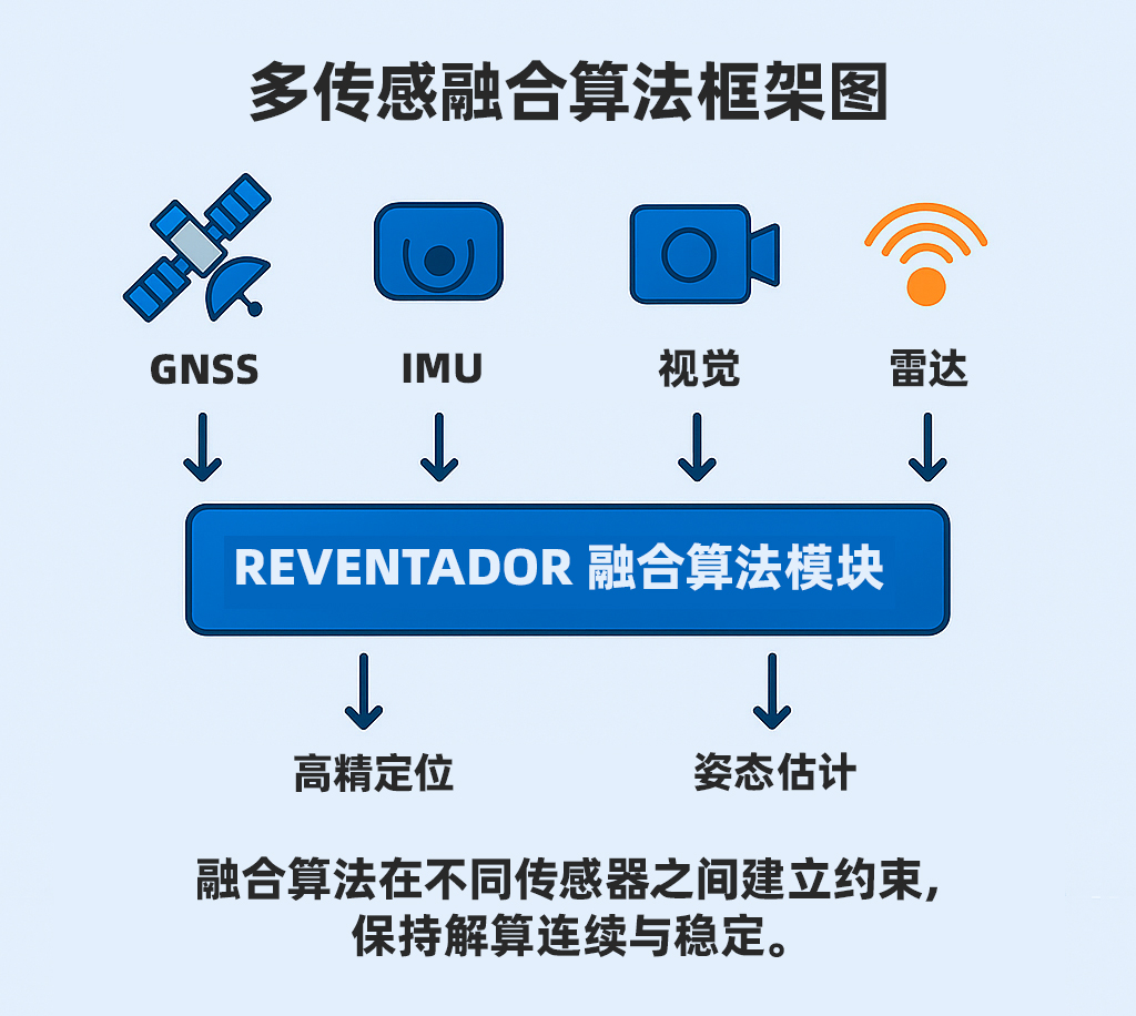
4. Fusion: Stopping Errors from Accumulating
Data from any single sensor carries noise and drift.
The goal of a fusion algorithm is to find the optimal balance across multiple sensors.
REVENTADOR employs both “tight coupling” and “deep coupling” strategies
to enforce real-time error constraints at the filter level.
GNSS provides absolute position information;
IMU delivers high-speed dynamic response;
Vision and radar supply relative spatial constraints.
When data from a particular sensor appears anomalous, the system automatically reduces its weighting,
keeping the overall solution stable.
This is not about “stacking more data” — it is about “understanding the data.”
Each data stream checks and corrects the others,
forming a spatiotemporal system capable of self-judgment.
Stability comes not from having more data, but from understanding it more deeply.
5. The Limits of Reliability: From “Positioning” to “Self-Healing”
In the autonomous driving and embodied intelligence systems of the future,
reliability will no longer be merely a technical specification —
it will be a systemic property.
The collaboration between MOJANDA, SUMACO, and REVENTADOR
represents a new system paradigm:
- The chip layer provides redundancy and interference resistance;
- The INS layer delivers continuity and compensation;
- The algorithm layer enables judgment and correction.
This layered, progressive design allows the system to recover on its own even in the most complex environments.
Much like a person feeling their way forward in the dark,
instinctively remembering direction and stride —
unable to see for a moment, yet never truly lost.
6. Reflections and the Road Ahead
Satellite signals will never be perpetually stable.
The denser our cities and the more complex our airspace,
the more frequent obstruction and interference will become.
The spatial intelligence systems of the future must learn to stay lucid in a world of signal blindness.
That means algorithms must understand uncertainty, hardware must tolerate complexity,
and systems must be able to recover from failure and rebuild from data.
True reliability is not about never falling — it is about being able to take flight again after you do.
Further Reading
- Paul D. Groves: Navigation Principles and Sensor Fusion
- Kaplan & Hegarty: Understanding GPS/GNSS: Principles and Applications
- Dana Mackenzie: The Math of Uncertainty: Navigating the Unknown
About MCT
MCT is an innovative company dedicated to attitude sensing and absolute positioning for the era of Physical AI. With artificial intelligence at the core of our technology, we follow a “data-driven, hardware-software integrated” strategy to develop and deliver comprehensive attitude sensing and absolute positioning solutions — serving the fields of embodied intelligence, urban-area assisted driving, low-altitude economy, robotics, and intelligent devices. Built on our proprietary automotive-grade BeiDou high-precision chips and modules, and combining high-precision IMU, vision, and radar sensor technologies with large-scale data, MCT provides more reliable, safer, and more accurate technical support for autonomous planning and automatic control, continuously enhancing the spatial perception capabilities of intelligent platforms.
Want to learn more about MCT’s latest developments? Visit www.mctech.ai / www.mctai.cn, or follow our WeChat official account “毫厘智能 MCT”.